
Mapping the Deep Blue Sea
As We See Above, So Shall We See Below

Welcome to Words with Wynn! If this is your first time perusing my content and you’d like more of my weekly musings, subscribe below:
SpaceX reignited the space race. With Elon’s success, a second order effect has been the proliferation of satellites in orbit, which has ushered in a golden age of geospatial imaging. The various constellations around Earth today provide rich, affordable, and accessible surface data of virtually the entire world. Not only that, but the exponential decline in launch prices has also inspired scientists to dream bigger and look deeper in the other direction as well, launching mind-blowing instruments like the James Webb Space Telescope in 2021.

So, we’re getting deeper views of space, clearer views of Earth, and yet our view of the ocean remains murky as Galveston Bay (Texas-specific joke, sorry). That’s no small segment of the map…
The ocean is big. Very big. 71% of the Earth’s surface. Yet 80% of the ocean’s floor still remains unmapped. Why?

Because gathering oceanic data is extremely expensive. As with all things, the problem historically was supply and demand. You previously would have had to run manned ships bristling with expensive sensors across large swaths of open sea through treacherous and variable weather conditions in order to build a comprehensive data set including unattractive segments of sea with little customer demand. Highly manual, sometimes dangerous, entirely unprofitable. Not great.
Fortunately (unfortunately), a confluence of factors have unlocked supply while global forces have accelerated demand for all kinds of marine of data:
Technology - we’ve come down the cost curves in robotics, edge computing, satellite connectivity/availability, solar panel effectiveness and cost, as well as advancements in battery technology
Global Warming - the effects of global warming have magnified our need to understand the changing oceanic landscape and intensifying weather patterns, and accelerated deep sea mapping projects like Seabed 2030
Geopolitical Uncertainty - South Seas geopolitical tensions have driven dollars into naval research, data, and readiness for the defense sector
So, we’ve got renewed interest and increasing access, but who’s making it happen?
As We See Above: Saildrone

Saildrone is probably the frontrunner in deploying uncrewed surface vehicles (USVs) for oceanic data collection. And let me tell ya, its Co-founder and CEO is exactly the kind of guy you’d want tackling this challenge. Richard Jenkins has been a lifelong sailor and engineer. He’s been working on ships since his teens, and has been obsessed with the technology of the craft ever since.
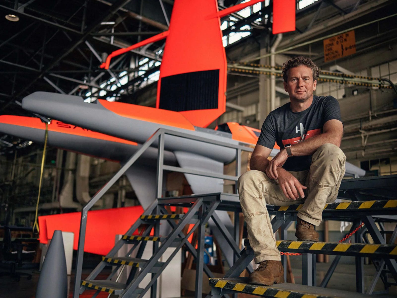
But more than that, he’s an absolute legend of a salty sea dog. Prior to founding Saildrone, Jenkins was obsessed with the art of speed sailing. More specifically, he was possessed by the challenge of breaking the land-speed record for a sail-powered vehicle. He devoted a decade of his life to the task, and achieved the record as the ‘fastest sailor on Earth’ in a Las Vegas lakebed in 2009, piloting his faithful Greenbird to 126 mph.

He’s not quite Shackleton, but I like to think they’d get along. Plus, Saildrone 1020 became the first unmanned vehicle to circumnavigate Antarctica. So they’d have plenty to discuss.
Today, Saildrone maintains a fleet approaching 200 vessels and its skiffs have autonomously sailed over 1.6 million nautical miles. The company was founded in 2012 by Richard Jenkins and Dylan Owens (who left the startup in 2014, per his LinkedIn), whose skillsets combined physical shipbuilding know-how with nautical autonomy expertise. The startup’s maiden USV voyage launched in 2013, sailing the first Saildrone prototype, The Honeybadger, from San Francisco to Hawaii over 34 days. Since then, the startup has deployed its fleet globally from the South Seas to Antarctica, and has developed multiple classes of vessel for varying use cases.
The Drones

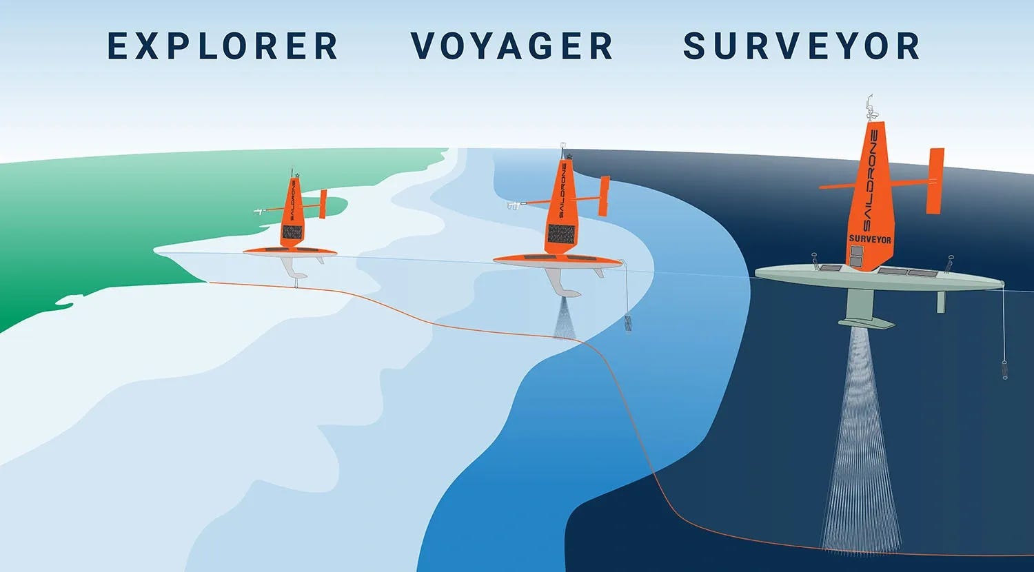
The Saildrone fleet today is comprised of three models:
Explorers (15ft): scientific data collection & single-beam ocean mapping
Voyagers (33ft): maritime domain awareness & ocean mapping
Surveyors (65ft): deep ocean multibeam mapping
The varying vessels can be outfitted with any number of capabilities:
“Each saildrone carries a payload of science-grade sensors to measure important atmospheric and oceanographic environmental variables in real time, map the seafloor in high resolution, and provide persistent maritime domain awareness. They have been deployed on data collection missions in the Arctic, Atlantic, North Sea, Tropical Pacific, South Pacific, Southern Ocean, Gulf of Mexico, and along the North American West Coast to track fish and mammals, measure how much carbon is being absorbed by the ocean, study why some hurricanes intensify so rapidly, and even stand in for disabled weather buoys.” - Saildrone (source)
The USVs are powered by a combination of solar and wind energy. Interestingly, it was Jenkins’s obsession with land sailing that birthed the innovative sail design that is integral to Saildrone’s edge. The carbon-fiber sail itself is effectively a vertically turned wing, which harvests the surrounding wind to generate ‘lift’ angled as propulsion to power the skiff forward. The odd-looking side structure jutting off the sail is a trim tab, which helps to angle the sail. Furthering the airplane comparison, if the sail itself were the ‘wing’ generating lift (propulsion) the trim tab would be the tail fins of the plane, adjusting via autopilot to steer. This works in concert with a rudder on the ship itself. This system allows the Saildrone units to travel in an incredibly energy-efficient manner, harvesting an infinitely renewable energy source for their movement. It’s also worth noting that this design is mechanically minimalist, which adds to the durability and longevity of the drones and helps to keep down costs.
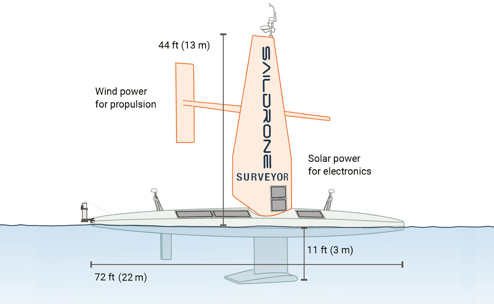
For the on-board electronics, solar power is captured via panels on the deck and sail of the ships. Leveraging these two renewable power sources enables Saildrone fleets to effectively run in perpetuity. This limited downtime is an obvious boon for driving down the cost of civilian use cases (oceanic mapping, marine life tracking, etc.), but also makes the Saildrone surveillance capabilities particularly appealing for governmental partners as well.
Maritime Domain Awareness (MDA) & Intelligence, Surveillance, and Reconnaissance (ISR)
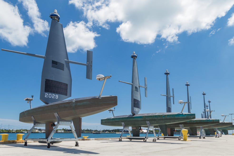
Saildrone began initial testing with the Navy in December 2021, where it deployed two fleets of Explorers to help monitor surface traffic in the Persian Gulf and Red Sea. From the success of those initial tests, the startup has continued to integrate its unmanned capabilities with armed forces partners. While precise fleet deployment statistics are scant, a few notable data points from Richard Jenkins’s testimony before the House Armed Services Committee a couple months ago (emphasis mine):
“Operational success in the Middle East led to expansion into the SOUTHCOM and NORTHCOM AORs [Areas of Responsibility] last year. There, a fleet of Voyagers has provided maritime ISR for counter trafficking operations continuously since September 2023. Quarterly reviews by the Office of the Undersecretary of Defense for Intelligence and Security (OUDSI) throughout the mission reported that saildrones were responsible for 96% of all surface contact detections in and around the Windward Pass and the Florida Strait with a 95% cost reduction relative to the daily operational cost of a Navy destroyer. Put another way, for the entire daily rate of one destroyer, Saildrone could provide complete maritime ISR coverage along every major Caribbean trafficking route to the United States. As in CENTCOM, our platforms have provided a decisive operational advantage in an area where demand for manned resources is high and availability is scarce. I am pleased to report that we will be doubling that fleet and expanding into INDOPACOM with additional drones this year, enabled through the DIU’s fielding budget line.”
Funding & Future
Venture investors always discuss the proverbial ‘10x solution’ as the kind of breakthrough where startups win. Saildrone has demonstrated precisely this kind of step change improvement over previous labor and cost intensive means of gathering oceanic data. Hence, with strong indications of PMF, the company continues racing to scale its fleet and widen its lead.
The progress thus far has been fueled by and attracted investment from a number of venture luminaries including Mary Meeker’s BOND Capital (a spinout of Kleiner Perkins’s growth fund), Lux Capital, and Tribe Capital, among others. Saildrone secured a $100M Series C in 2021 to continue fueling its goal of quantifying the entire planet.
So Shall We See Below: Seatrec

Unfortunately, not all data points are so easily gathered from the surface. Although USVs are being equipped with increasingly sophisticated sensors, creating a detailed picture of the ocean requires a mosaic of data types, some of which are best gathered at depth.

That’s where Seatrec comes in:

Seatrec has developed a novel technology that leverages gradient changes in oceanic temperatures to generate clean, renewable power for undersea robots. The startup’s modular platform can dramatically enhance (10x+) battery life while simultaneously unlocking new sensor capabilities that had previously been uneconomic to deploy due to their power demands.
One of the primary bottlenecks of deep ocean observation is energy consumption. Where Saildrones can leverage solar and wind to fuel their voyages, bots deployed at depth don’t have that luxury. This makes it incredibly costly to gather deep-sea data– researchers were previously stuck between a rock and a hard place of either paying mountains of cash to manually retrieve and recharge their expensive equipment when it died or losing heaps of pollutive hardware to Davy Jones’s Locker. Either option made this data untenable to gather for generalized use cases. Plus, one can imagine clandestine interests where a surface trawling vessel may not be the ideal medium for intelligence gathering.
The Technology

Seatrec’s technology was developed by Dr. Yi Chao and his team at NASA’s Jet Propulsion Lab over a decade ago (surprise, surprise - NASA is one of the largest gatherers of oceanic observation data). After initial validation, Dr. Chao saw the potential for Seatrec’s solution to dramatically enhance deep sea mapping capabilities, and began leveraging federal grants to hack away at commercializing this innovation. What started as an attachment to extend the life of third party machines has since evolved into the startup’s infiniTE Float, a modular platform that customers can outfit with sensors of their choosing.
But how does it work?

Seatrec is a portmanteau of Sea + Thermal + Recharging. Its underlying technology leverages thermal changes in the ocean to harness energy. Within the float is a small loop containing Phase Change Materials (PCMs), chemicals which easily phase shift from solid-to-liquid/liquid-to-gas, attached to a motor. At varying temperatures, the PCMs transform, changing volume as they expand/contract in various states. These volumetric changes then drive pressurized fluids through a motor which generates electricity. In Seatrec’s case, its internal PCMs freeze/expand as the float descends to cooler, deeper depths and melt/contract as the float surfaces to relay data. This generates enough power to significantly extend float battery life nearly indefinitely, and even unlocks new use cases requiring more power-hungry sensors.
Use Cases

Seatrec’s technology shares a number of similar use cases to Saildrone’s, with a few additional bells and whistles. Seatrec floats can be utilized for seafloor mapping and general data gathering (temperature, acidity, etc.), but they also have unique applications for weather tracking, soundscape monitoring, and potentially UAV recharging.
Both Saildrone and Seatrec technologies are being used to gather meteorological data. As storms intensify and long-tail events occur with more frequency, the ability to disperse tracking technologies across the ocean continues to gain relevance. For example, deploying a fleet of floats across the Gulf of Mexico can empower meteorologists with visibility into surface temperature data that helps predict how much a hurricane might intensify as it approaches land. To that end, Saildrones have been deployed in a number of hurricanes, even sailing directly into the eye of the storms.
One key advantage to Seatrec’s technology is accessing the Sound Fixing and Ranging Channel for acoustic monitoring as well as undersea communication. The SOFAR is a channel around 600 to 1,200 meters beneath the ocean’s surface where sound waves can travel over extremely long distances. This effect occurs due to a unique combination of temperature, pressure, and salinity at that depth.

The SOFAR channel is leveraged by biologists for tracking undersea wildlife like whales, but it also has a number of important use cases for submarines as well. For naval applications, it is used for both listening (intelligence gathering) as well as guidance/communications. Acoustic beacons can be placed at depth as an additional means for submarines to triangulate their position. This channel is also tapped for reconnaissance, listening to the movement of vessels etc. While USVs like Saildrone can certainly eavesdrop into the SOFAR channel via towed hydrophones, constant monitoring from extended life floats like Seatrec’s are a stealthier way to achieve this in more sensitive seas like contested waters.
Finally, Seatrec’s technology is also being explored for some more sci-fi type use cases like underwater power stations or arctic energy bases. In a next generation conflict, autonomous undersea vehicles will be utilized at scale, but powering and recharging these machines remains a challenge. To address this need, Northrop Gruman partnered with Seatrec to test use cases of attaching its power generation technology to Unmanned Underwater Vehicle Stations. It is also speculated that this type of technology may be utilized to power next generation UUV’s like the Navy’s Manta Ray:

Seatrec has also collaborated with the Navy to blueprint power stations in the Arctic, which are largely powered by diesel during times of the year with limited sunlight.
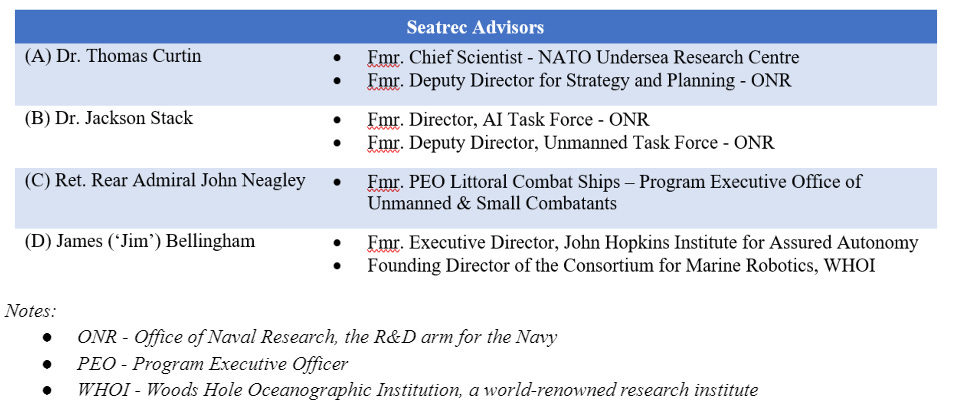
Although its energy output continues to be optimized, the Seatrec platform has secured backing from investors like Dr. Norge Larson, previous President of Sea-Bird electronics (one of the most successful BlueTech exits in recent years), who led the company’s $2M Seed Round. The startup has also attracted a roster of heavy hitting advisors as well:
Conclusion: How Big Could This Be?
The Blue Economy is a market as large as the ocean is vast:
“The Blue Economy – sustainable, ocean-centric commerce – is expected to generate more than $3T in global economic impact and support more than 40M jobs around the world, according to the Organization for Economic Co-operation and Development (OECD). Aquaculture alone is projected to grow into a $274B per year market by 2025.” - Seatrec Press Release
The TAM for specific startups like Seatrec and Saildrone can be challenging to triangulate, given the variety of use cases their technologies address. But a few relevant data points I dredged up for scale include markets like the spend expected on Oceanographic Monitoring Systems ($2.2B) and Ocean Observation Instruments ($14.8B) by 2030. One can also back into reasonable market-sizes with military and academic budgets for ocean research which reach into the tens of billions as well.
These markets represent an opportunity for entrepreneurs to do good while doing well. The success of startups like Saildrone and Seatrec is integral to accumulating high-fidelity maritime data on a global scale. The treasure troves of data their platforms are collecting help to filter our murky understanding of the world’s oceans and our effects on them.
Cheers,
- 🍋